Longest Dam In India :
Hirakud Dam(Odisha):
| Total length : 25.79km |
| Length of main dam : 4.8km |
| River : Mahanadi |
| Year : 1957 |
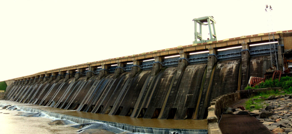
This dam is built across the Mahanadi river, about 15km from Sambalpur in Odisha. Behind the dam extend a lake, Hirakud reservoir,55km long. The construction of this dam began on 1947 and open on 1957.Its estimates cost is 1.01billion rupees in 1953. Its length is 4.8km(main section) and 25.8km(entire dam) The vast expanse of the Dam and its surrounding waters is a sight for sore eyes. Scores of tourists visit the area to take in the views and the engineering marvel that is the Hirakud Dam. The bulk of the Dam contains earth and concrete enough to construct a road 8 meters wide – from Kanyakumari in the south to Kashmir in the north, and further across from Amritsar to Assam.
Lost Temples in the Waters of Hirakud:
The cost of development and progress is often substantial. In the case of Hirakud, construction led to the complete destruction of several temples which were submerged after the Dam was completed in 1957. If you happen to visit in summer, the receding waters of the Dam will reveal these lost structures underneath. The forgotten stories of these temples have caught the attention of historians. Efforts have begun to document the historical significance of these temples. While many temples have been destroyed after 58 years underwater, around 50 have stood the test of water and time. Their structures resurface now and then, reminding us of lost stories and a different period in time. More than 200 temples were lost in the construction of the Dam. The waters of the Hirakud Dam provide excellent opportunities for archaeology buffs and scuba diving enthusiasts to explore the remnants of forgotten history. The hidden temples are visible to boating visitors during the summer months of May and June.
Displacement Causes Misery:
The dam’s primary objective was to control flooding in the Mahanadi delta. Secondary objectives included providing water for irrigation and drinking, generating hydropower, aiding fisheries and navigation. It irrigates a total area of 267,494 hectares in the districts of Sambalpur, Bargarh, Sonepur and some parts of Bolangir in western Odisha through the Bargarh canal on the right bank However, in doing all this, it has submerged more than 360 villages covering more than 1,23,000 acres of land and displaced 26, 561 families (more than one lakh people). The government of India had promised all basic amenities to those displaced. This included agricultural lands with irrigation facilities, education and health services in the resettled areas. They were also to be employed to compensate for what they lost out on, but these promises have only remained as promises over the last six decades.
No proper rehabilitation or compensation:
“The compensation paid by the government was not enough to purchase new agricultural land and a house. Displaced people in the area have settled down due to their own initiatives. The government in its order has assured pattas (land) for housing and agriculture but till date none of the displaced have got these pattas”, says Shrikant, a resident of Jugipali village in Sambalpur.
How to Reach Sambalpur:
By Road: Sambalpur is connected by National Highway 6. This Highway from Mumbai to Kolkata passes through Sambalpur. Sambalpur is connected to Bhubaneswar through National Highway 42. Sambalpur has two bus stands – one for private vehicles and the other for Government transport. The Govt. Bus stand is located at Laxmi Talkies Chhaka, and the Private Bus stand is located at Ainthapali, about 3 km from the Govt Bus stand.
Oldest Dam In India :
Kallanai Dam (Tamil Nadu):
| River : Kaveri |
| Year : 100 BC- 100 AD |
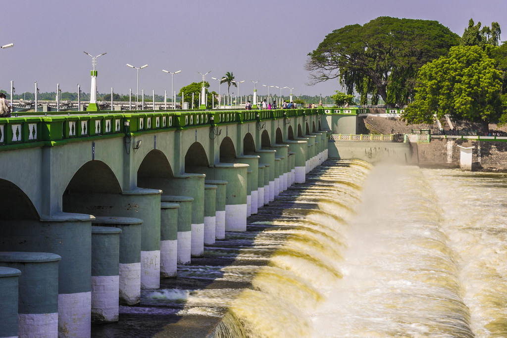
Kallanai (also known as the Grand Anicut) is an ancient dam. It is built (in running water) across the Kaveri river flowing from Tiruchirappalli District to Thanjavur district. The purpose of the Kallanai was to divert the waters of the Kaveri across the fertile delta region for irrigation via canals and to its northern delta branch Kollidam/Coleroon. Downstream of the barrage, the river Kaveri splits into four streams known as Kollidam Aru, Kaveri, Vennaru and Puthu Aru. However, the flood waters can be allowed, by opening the barrage/anaicut gates, to pass through the other three delta branches also to join the sea. It is constructed from unhewn stone spanning the Kaveri and is 329 m (1,079 ft) long, 20 m (66 ft) wide and 5.4 m (18 ft) high. The dam is still in excellent condition, and supplied a model to later engineers, including Sir Arthur Cotton’s 19th-century dam across the Kollidam, the major tributary of the Kaveri. The unique design and its effective functioning amazed the British in 1800s many years later and their military engineers were asked to study the river and the ancient dam. With an aim to increase irrigated area the British built another dam downstream by replicating the one made by Karikalan Chola. The Lower Anicut was built by Sir Aurthur Cotton in 19th century on a major tributary of River Kaveri. The dam is made of unhewn stone and is 1,080 feet long and 60 feet wide, across the main stream of the Cauvery. The area is irrigated by the ancient irrigation network of which the dam was the centerpiece, covering about 69,000 acres. By the early 20th century, the irrigated area had increased to about 1,000,000 acres.
History:
Built around 2,000 years ago across the Kaveri River in Tiruchirappalli District, Tamil Nadu, by Karikala Chola, the dam was constructed to divert the river to the delta districts thereby boosting irrigation and avoiding loss of crops due to floods. The dam though very old has a strong foundation and a solid structure. It is still in excellent condition and is used as a major irrigation dam in Tamil Nadu. The dam has also been an inspiration for many recent modern day dams due to its amazing engineering. Due to its impressive architecture, the dam attracts a lot of tourists every year. The unique structure of the Kallanai dam involves large stones sunk in the Cauvery river to divert the water flow to the fertile delta. The main function of the dam was to retain the water supply in the Cauvery and flow the surplus into Coleroon through the Ullar river. The dam was re-modeled by the British during the 19th century.
What is an Anicut?
This is a dam built across a stream or river for maintaining and regulating irrigation. In terms of function, a dam can clearly do more than the Grand Anicut. A standard dam has the ability to divert and retain water from a large water source for water supply and power generation. The Grand Anicut, on the other hand, was designed to retain water and divert the surplus to irrigate lands. The Grand Anicut also is known as the Kallanai Dam is a simple check dam constructed across the direction of flow of the Kaveri river in order to divert water into the fertile delta of Tamil Nadu. Its unique structure majorly involves several large unhewn stones extending across the Kaveri, stuck in the Cauvery river to divert the flow of current to the fertile delta. The dam is 329 meters long, 20 meters wide and 5.4meters high. It was able to irrigate 69,000 acres of land in the fertile delta. One of India’s oldest surviving dams is nothing short of a national treasure. It is a structure passed down to several generations and still serves the populace around it. This makes the design truly an inspiration for the largest dams we use today.
How to reach there?
Kallanai dam is located 19 kms. from Tiruchirappalli, and the nearest airport is the Tiruchirapalli airport, about 13 kms. away from the dam site. The nearest railway station to Kallanai Dam is Lalgudi railway station Junction which is 4 kms. away from the Kallanai Dam.
Highest Dam In India :
Tehri Dam(Uttarakhand) :
| Total length : 575m |
| Height of dam : 260m |
| River : Bhagirathi |
| Year : 2006(1st phase) |

The Tehri dam is a multi-purpose rock and earth-fill embankment dam on the Bhagirathi river near Tehri in Uttarakhand, India. Tehri is situated 200 miles north-east of New Delhi. With a height of 260.5 metres, Tehri dam is the tallest dam in India, second tallest in Asia and eighth tallest in the world. A pilot investigation for the Tehri Dam Project was conducted in 1961. The design of the dam was completed in 1972. Based on the study, a 600 MW capacity power plant was approved. Being a multipurpose dam, Tehri dam supplies large amounts of electricity as well as drinking and irrigation water to greater part of Northern India, including the country’s capital city of Delhi. The dam has Francis pump turbines with an installed capacity to produce 1000 MW of power with an additional 1000 MW of pumped storage hydroelectricity. The Tehri Hydropower Complex also includes the 400 MW Koteshwar Dam. The maximum planned capacity of Tehri dam is 2400 MW. The electricity produced from the dam is distributed to Uttar Pradesh, Uttarakhand, Punjab, Delhi, Haryana, Jammu & Kashmir, Chandigarh, Rajasthan and Himanchal Pradesh. The dam would also provide irrigation to an area of 670,000 hectares and supply 270 million imperial gallons of drinking water per day to industrialized area of Delhi, Uttar Pradesh and Uttarakhand.
The Tehri Dam is the tallest dam in India. It is a multi-purpose rock and earth-fill embankment dam on the Bhagirathi River near Tehri in Uttarakhand, India.
At the time when Tehri Dam was made State Government (Uttarakhand) has decided to to convert the famous Tehri Lake into an Adventure Tourism. Tehri Lake includes many different and varied activities from Jet Skiing to Hot air ballon rides.
In the name of Adventure sports the people of our country had limited options and traveled to other places to quench their thirst of adventure, but now it is all going to change. With the rise of adventure sports in India, the Government of Uttarakhand is planning to change the famous Tehri Lake into a major Adventure tourism destination.
Here’s the list of Adventures Activities in Tehri Lake :
- Boating
- Jet Speed Boar Ride
- Water Skiing
- Zorbing
- Banana Boat Ride
- Bandwagon Boat Ride
- Hotdog Ride
- Paragliding
Tehri Dam Project trapped in Environmental Issue:
The Tehri valley in the Garwhal Himalayas has for decades been the ideal advertisement for peace and rustic tranquility. But the valley and its in habitants, are now hostage to progress, trapped in the all-too-familiar cross-fire between doomsayer ecologists and officials in charge of the ambitious Tehri Dam Project (TDP).
Located at the confluence of the Bhagirathi and Bhilangana in Uttar Pradesh, the valley has been engulfed in controversy as the proposed Rs. 2,200-crore project, mooted back in the ’60s, became a reality after the Soviet agreement to provide financial aid. Charges Prem Singh, a journalist and social worker who is spearheading the campaign to stop the project: “Ecological considerations have been largely ignored. The construction of the dam is a political decision.”
Singh and the ecologists who echo his strident objections have collected an impressive mound of evidence to support their stand. One prominent exhibit is the letter to the Government written by Sunil Roy, chairman of the Working Group set up by the Department of Environment to study the ecological consequences of the project.
Dams = Habitat Destruction :
Any dramatic change in river composition stresses both up- and downstream habitats. Habitat loss is the leading cause of extinction.
Dams disrupt fish and bird migration. The change in the composition of the river interferes with the chemical signals guiding species through their biological processes. And the physical barrier of the dam blocks species from their traditional spawning and rearing locations. As a result of this, pollution, and the effects of climate change, fresh water species have lost 76 percent of their populations since 1970.The Snake river running through the Northwestern United States, for example, has 15 dams! Since the completion of the Lower Granite Dam in 1975, the population of Sockeye Salmon in the region has severely declined; between 1985 and 2007, only about 18 Sockeye Salmon return to Idaho each year.
Additionally, changes in the timing and flow of the rivers can create conditions which threaten the survival of the species that have evolved to live there. Any alteration in the structure and composition of the river can have disastrous effects on the surrounding species, in many cases leading to extinction.
Downstream ecosystems suffer from the lack of sedimentation in the water that flows over the dam. Normally, nutrient rich sediment regulates and provides nourishment to downstream habitats. But reduced sedimentation creates less fertile soil, stunting the growth of dependent species. The lack of vegetative growth can lead to erosion and to the destabilization of the surrounding areas.
Downstream habitats are also severely impacted by changes in salinity and oxygen levels. Due to the high rate of evaporation and growth of aquatic vegetation within the reservoir itself, water that travels downstream from a dam usually has a higher salinity content and a lower oxygen concentration than normal. This change in the chemical makeup of the water creates detrimental conditions for species that previously thrived in those areas.
Dams also negatively impact ecosystems and habitats upstream. Trapped river borne nutrients can facilitate the growth of toxic algae blooms. Communities around the world from South Africa to California have had to impose drinking and swimming bans to protect people from water-borne illnesses. Some dams have killed off fisheries and entire aquatic ecosystems.
Dams = Earthquakes :
Scientists have attributed over 100 earthquakes around the world to dams and reservoirs, a phenomenon known as Reservoir Induced Seismicity. This happens when extra water seeps into the micro-cracks and fissures under the reservoir and surrounding areas and lubricates faults already under tectonic strain. The 7.9 Sichuan Earthquake in China in 2008, killed 80,000 people and has been linked to the construction of the Zipingpu Dam.
Reaching Tehri Lake :
Koti Colony is the nearest point to Tehri Lake. Koti Colony serves as a residential complex for all the employees working at the Tehri Dam, but pretty soon it will develop into a one-stop destination for all your adventure needs. The government is planning to promote adventure tourism at Tehri Dam and is taking some big initiatives for the same. Koti Colony will act as the administrative unit to promote all adventure related activities. Tehri Dam is at a distance of just 20km from the Koti Colony and can be reached via Chamba. If you plan to visit the Tehri Dam, you can plan your stay in Chamba, which is one of the most beautiful places in Uttarakhand.
By Air: Located at a distance of around 87 km, Jolly Grant Airport also known as Dehradun Airport is the nearest airport to reach New Tehri. Cabs are easily available from Dehradun to New Tehri.
By Rail: Deboard at Rishikesh railway station to reach New Tehri as it is situated some 73 km away from your destination. Taxis and buses from the railway station are easily available.
By Road: As New Tehri is well connected via roads, it’s easy to reach here via buses and taxis from places in Uttarakhand like Mussoorie, Rishikesh, Haridwar, Devprayag, Srinagar, Uttarkashi and more.
People visit this amazing place to enjoy the water sports adventure at Tehri Lake that have gained a lot of popularity over the years. From Jet Skiing to Hot air balloon rides, Tehri has been revamped to include many varied and different activities. From India and all across the globe, tourists visit this amazing place to enjoy water sports and other adventure activities. You don’t want to miss out on the banana boat ride here. From the dock, you will ride out to the marina in luxury skis and then be transferred to the Banana Boat..
very good information ,the descriptions given a very much precise and in detail.thank you