
Table of Contents
1. What Is a Glacier?
Definition of Glacier
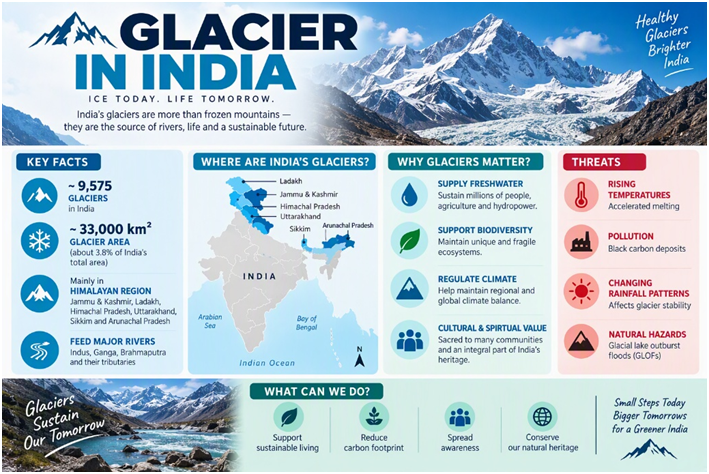
A glacier is a large, long-lasting mass of compacted snow and ice that flows slowly under the influence of gravity. Unlike ordinary snowfields, glaciers are dynamic. They accumulate snow, convert it into dense ice and gradually move downhill or outward. Glaciers in India are permanent masses of snow and ice that move slowly under their own weight. Most Indian glaciers occur in the Himalayas and the Karakoram, where they feed the Indus, Ganga and Brahmaputra river systems. The Nepal Flood, a major glacier-related disaster occurred in Nepal in August 2026, when a large ice-and-rock mass collapsed in the Langtang Lirung region, triggering a destructive debris flow and flooding.
This article covers the largest glacier in India, important glaciers, state-wise distribution, glacier map guidance, rivers originating from glaciers, climate change, and MCQs.
Types of Glaciers
1. Valley glaciers: These glaciers flow through mountain valleys. They are the most common type in the Himalayas.
Examples:
- Gangotri Glacier
- Pindari Glacier
- Milam Glacier
- Zemu Glacier
2. Cirque glaciers: These are small glaciers occupying bowl-shaped depressions called cirques or corries.
3. Piedmont glaciers: A valley glacier may spread outward when it reaches a relatively broad or flat area. This produces a piedmont glacier.
4. Hanging glaciers: These glaciers are located on steep mountain slopes or above the main valley glacier. Their ice may break off and cause avalanches.
5. Ice caps and ice sheets: Ice caps cover extensive highland areas, while ice sheets cover vast continental areas. India does not have continental ice sheets; its glaciers are primarily mountain or valley glaciers.
Examples:
- Antarctic Ice Sheet
- Greenland Ice Sheet
2. Nepal Flood 2026 and Glacier Collapse:
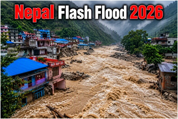
The importance of understanding glaciers has become especially evident with the devastating Nepal flood disaster of August 2026. On 26 August 2026, a large mass of ice and rock collapsed from the high-altitude Langtang Lirung area near the Nepal–Tibet border. The collapse generated a powerful flow of ice, rock, water and sediment that travelled downstream through the Lhende/Bhotekoshi river system, causing catastrophic flooding and extensive destruction. Satellite and geological assessments indicate that the event involved a major ice–rock avalanche and debris flow, rather than being simply a conventional river flood.
Was the Nepal flood caused by glacier melting?
Glacier melting alone was not the direct cause. The immediate event was the collapse of an ice-and-rock mass, which then generated a destructive debris and flood flow. However, scientists have linked the increasing instability of Himalayan high-altitude environments with rising temperatures, glacier retreat and the weakening of ice and frozen ground.
A recent scientific attribution analysis reported that extreme warming likely increased the instability of the glacier and surrounding mountain slope, while also noting that climate change was not the sole factor involved. This distinction is important for understanding glacier-related hazards: Glacier warming/retreat → destabilisation of ice and mountain slopes → ice/rock collapse → debris flow or flood
In other situations, glacier melting can also contribute to the growth of glacial lakes. If a natural moraine or ice dam fails, the sudden release of water can produce a Glacial Lake Outburst Flood (GLOF).
Therefore, the Nepal disaster provides an important real-world example of why changes in the Himalayan cryosphere can create serious risks for downstream communities.
3. Glaciers in India: Overview
How many glaciers are there in India?
According to the Geological Survey of India (GSI) inventory, the Indian Himalayan Region has about 9,575 glaciers, covering roughly 37,466 sq km. These glaciers occur mainly in the Union Territories of Jammu and Kashmir and Ladakh, and in Himachal Pradesh, Uttarakhand, Sikkim and Arunachal Pradesh.
Note: The figure comes from the GSI inventory and may differ from newer inventories because glacier counts depend on mapping methods and minimum-area thresholds.
Why are glaciers important?
Indian glaciers are important because they:
- Store freshwater.
- Feed Himalayan rivers.
- Support agriculture downstream.
- Contribute to hydropower generation.
- Maintain river flow during dry periods.
- Support mountain ecosystems.
- Influence regional climate and hydrology.
- Create tourism and trekking opportunities.
- Have strategic importance in high-altitude border regions.
The Himalayan glaciers are especially important to the Indus, Ganga and Brahmaputra river systems.
Main glacier systems in India
Indian glaciers are mainly divided into two broad geographical systems:
- Karakoram Glacier System
- Himalayan Glacier System
- Karakoram Glacier System-
The Karakoram is a heavily glaciated mountain range extending across India, Pakistan and China. Siachen Glacier, located in Ladakh, is one of the major glaciers associated with the Indian part of the Karakoram. Baltoro, Biafo and Hispar are major Karakoram glaciers, but they are located in Gilgit-Baltistan, Pakistan, and therefore should not be counted as glaciers of India. In exam questions concerning Indian territory, the Siachen Glacier is the most important.
2. Himalayan Glacier System-
The Himalayan glaciers extend from Jammu and Kashmir and Ladakh in the west to Arunachal Pradesh in the east.
Important Himalayan glaciers include:
- Gangotri
- Yamunotri
- Zemu
- Milam
- Pindari
- Bara Shigri
- Chhota Shigri
- Satopanth
- Kedarnath
- Dokriani
The Indian Himalayan glaciers lie within the drainage basins of the:
- Indus
- Ganga
- Brahmaputra
Also Read : UNESCO Sites In India 2026: Sarnath, Moidams& Raigad Fort
4. Distribution of Glaciers in India
4.1 Jammu and Kashmir
The high mountain regions of Jammu and Kashmir contain glaciers associated with the Kashmir and Ladakh mountain systems.
Important glaciers include:
- Kolahoi Glacier
- Machoi Glacier
- Drang-Drung Glacier
- Thajiwas Glacier
- Nun-Kun Glacier
The Kolahoi Glacier is one of the most important glaciers of the Kashmir Valley. It feeds streams that contribute to the Jhelum river system.
4.2 Ladakh
Ladakh contains some of India’s most extensive glaciers because of its high altitude and location in the Karakoram and Zanskar regions
Important glaciers include:
- Siachen Glacier
- Drang-Drung Glacier
- Rimo Glacier
- Kangsze Glacier
- Parkachik Glacier
- Khardung Glacier
- Chong Kumdan Glacier
Ladakh is a cold desert, but its glaciers are vital sources of meltwater for local rivers and settlements. Siachen Glacier, located in the eastern Karakoram, Siachen is the most important glacier for competitive examinations.Its meltwater gives rise to the Nubra River, which eventually joins the Shyok River of the Indus system.
4.3 Himachal Pradesh
Himachal Pradesh has several important glaciers in the Pir Panjal, Dhauladhar and Great Himalayan ranges.
Important glaciers include:
- Bara Shigri
- Chhota Shigri
- Miyar Glacier
- Bhaga Glacier
- Sonapani Glacier
- Parbati Glacier
- Kangriz Glacier
- Lady of Kedarnath Glacier
The Bara Shigri Glacier is the largest glacier in Himachal Pradesh. It is located in the Chandra Valley of Lahaul and Spiti.
4.4 Uttarakhand
Uttarakhand has important glaciers in the Garhwal and Kumaon Himalayas. Several major rivers and pilgrimage centres are closely connected with these glaciers.
Important glaciers include:
- Gangotri
- Yamunotri
- Pindari
- Milam
- Kafni
- Sunderdhunga
- Satopanth
- Bhagirath Kharak
- Dokriani
- Chorabari
- Kedar Bamak
- Nanda Devi Glacier
Uttarakhand’s glaciers are important sources of the Ganga and Yamuna river systems.
4.5 Sikkim
Sikkim’s glaciers occur mainly around the Kanchenjunga massif and the northern and eastern high-altitude regions.
Important glaciers include:
- Zemu
- Rathong
- Lonak
- Lhonak
- South Lhonak
- Talung
- Onglaktang
- Simvo
The Zemu Glacier is the largest and most important glacier in Sikkim. It lies on the eastern side of Kanchenjunga and contributes to the Teesta river system. It is widely described as the largest glacier in the Eastern Himalayas. It is approximately 26 km long according to commonly cited geographical sources.
4.6 Arunachal Pradesh
Arunachal Pradesh contains glaciers in the eastern Himalayas, especially in the Tawang, West Kameng, Upper Siang, Dibang and Anjaw regions.
Important glaciers include:
- Khangri Glacier
- Kangto Glacier
- Tawang Glacier
- Chong Kumdan Glacier
- Mago Glacier
- Sela Glacier
- Namka Chu region glaciers
Glacier data from Arunachal Pradesh can be more difficult to obtain because of its remote terrain, heavy snowfall, rugged topography and limited accessibility.
5. Largest Glacier in India
Siachen Glacier
The Siachen Glacier is generally considered the largest and longesglacier in India.
Location-
Siachen is located in:
- Eastern Karakoram Range
- Ladakh
- Nubra Valley region
- Near the India–Pakistan Line of Control
The glacier lies close to the strategically important Saltoro Ridge.
Length of Saichen Glacier-
Siachen is commonly described as extending for more than 70 km. Some official tourism information places its length at over 76 km.Because glacier measurements may differ according to the selected terminus and satellite or survey method, published figures should be treated as approximate.
Importance of Siachen Glacier
Siachen is important for several reasons:
- It is the largest glacier in India.
- It is located in a strategically sensitive region.
- Its meltwater contributes to the Nubra River.
- The Nubra River joins the Shyok River, which is part of the Indus drainage system.
- It occupies a key position near the Saltoro Ridge.
- It has major significance for India’s national security and high-altitude military operations.
6. Top Important Glaciers in India
| No | Glacier | Mountain Range / Region | River / Key Fact |
|---|---|---|---|
| 1 | Siachen Glacier | Karakoram Range, Ladakh | Largest glacier in India; strategically important |
| 2 | Gangotri Glacier | Garhwal Himalayas, Uttarakhand | Source of the Bhagirathi River; Gaumukh is the snout |
| 3 | Zemu Glacier | Eastern Himalayas, Sikkim | Largest glacier in Sikkim; associated with the Teesta basin |
| 4 | Bara Shigri Glacier | Pir Panjal / Lahaul Himalaya, Himachal Pradesh | Largest glacier in Himachal Pradesh; feeds the Chandra River |
| 5 | Milam Glacier | Kumaon Himalayas, Uttarakhand | Located in the Goriganga basin |
| 6 | Kolahoi Glacier | Kashmir Himalayas, Jammu & Kashmir | Important source of the Lidder River |
| 7 | Pindari Glacier | Kumaon Himalayas, Uttarakhand | Source region of the Pindar River |
| 8 | Chorabari Glacier | Garhwal Himalayas, Uttarakhand | Source of the Mandakini River |
| 9 | Drang-Drung Glacier | Zanskar Range, Ladakh | One of the major glaciers of the Zanskar region |
| 10 | Machoi Glacier | Kashmir Himalayas, J&K–Ladakh region | Located near Zoji La; important glacier of the Kashmir–Ladakh region |
| 11 | Satopanth Glacier | Garhwal Himalayas, Uttarakhand | Located in the Alaknanda basin |
| 12 | Khatling Glacier | Garhwal Himalayas, Uttarakhand | Source region of the Bhilangana River |
| 13 | Chhota Shigri Glacier | Lahaul Himalaya, Himachal Pradesh | Important glacier in the Lahaul region |
| 14 | Sonapani Glacier | Lahaul Himalaya, Himachal Pradesh | Located in the Lahaul region |
| 15 | Bhagirathi Kharak Glacier | Garhwal Himalayas, Uttarakhand | Part of the Gangotri glacier system |
| 16 | Kedarnath Glacier | Garhwal Himalayas, Uttarakhand | Associated with the Kedarnath and Mandakini region |
| 17 | Rimo Glacier | Eastern Karakoram, Ladakh | Major glacier system in the eastern Karakoram |
| 18 | Kangri Glacier | Karakoram, Ladakh | Glacier associated with the Karakoram region |
| 19 | Dafdar Glacier | Karakoram, Ladakh | Glacier of the Ladakh–Karakoram region |
| 20 | Kangto Glacier | Eastern Himalayas, Arunachal Pradesh | Associated with the high-altitude eastern Himalayan region |
7. State/UT-wise List of Glaciers in India
| State/Union Territory | Important Glaciers |
|---|---|
| Jammu and Kashmir | Kolahoi, Machoi, Thajiwas, Nun-Kun |
| Ladakh | Siachen, Rimo, Drang-Drung, Parkachik, Khardung, Kangsze |
| Himachal Pradesh | Bara Shigri, Chhota Shigri, Miyar, Bhaga, Sonapani, Parbati |
| Uttarakhand | Gangotri, Yamunotri, Pindari, Milam, Kafni, Satopanth, Dokriani, Chorabari |
| Sikkim | Zemu, Rathong, South Lhonak, Talung, Simvo, Onglaktang |
| Arunachal Pradesh | Kangto, Tawang, Mago, Sela and glaciers of the Dibang and Anjaw regions |
8. Glaciers in India Map
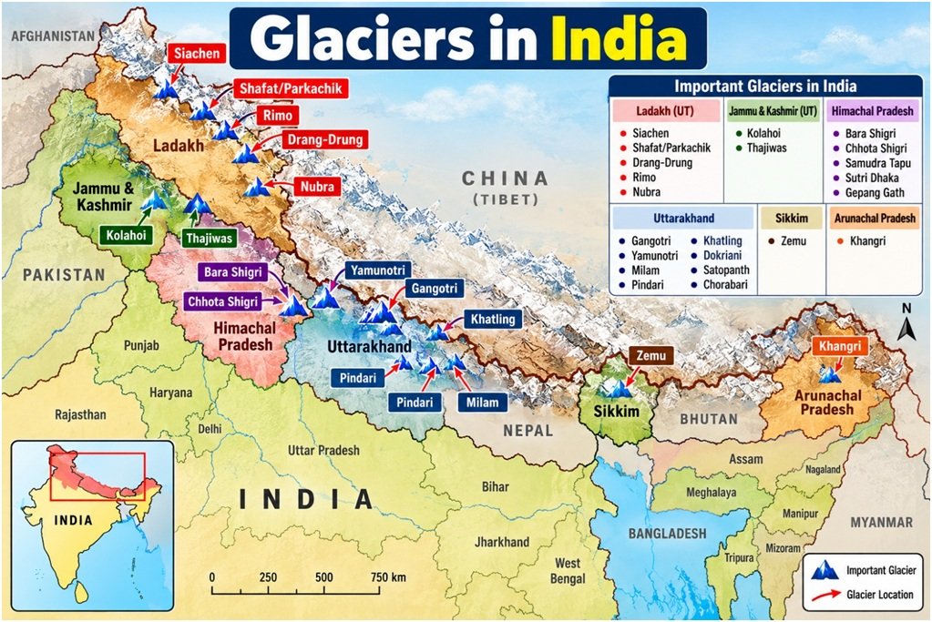
A good glaciers in India map shown in this following belts:
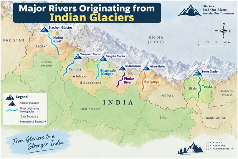
9. Major Rivers Originating from Indian Glaciers
9.1 Gangotri Glacier and the Ganga
The Bhagirathi emerges from the Gaumukh terminus of the Gangotri Glacier. The Bhagirathi is considered the source stream of the Ganga. It meets the Alaknanda at Devprayag, after which the combined river is called the Ganga.
9.2 Yamunotri Glacier and the Yamuna
The Yamuna originates from the Yamunotri Glacier near the Bandarpunch peaks in Uttarakhand. The Central Water Commission identifies the Yamunotri Glacier as the source of the Yamuna.
9.3 Zemu Glacier and the Teesta
The Zemu Glacier is located in northern Sikkim near Kanchenjunga. It is associated with the Teesta river system. Sikkim government material describes the Teesta as emerging from glacier and glacial-lake systems in the high Himalaya.
9.4 Pindari Glacier and the Pindar River
The Pindar River originates from the Pindari Glacier in the Kumaon Himalaya of Uttarakhand.. It later joins the Alaknanda at Karnaprayag.
9.5 Milam Glacier and the Goriganga
The Goriganga River originates near the Milam Glacier in the Pithoragarh region of Uttarakhand. It flows through the Johar Valley.
9.6 Siachen Glacier and the Nubra River
Meltwater from Siachen contributes to the Nubra River. The Nubra joins the Shyok, which ultimately belongs to the Indus river system.
Also Read : Transportation In India: Roadways, Railways, Airways, Waterways
10. Climate Change and Indian Glaciers
a) Glacier melting
Indian glaciers are sensitive to changes in:
- Temperature
- Snowfall
- Rainfall
- Western disturbances
- Black carbon deposition
- Dust and debris
- Extreme precipitation
- Changes in monsoon patterns
A 2025 Ministry of Earth Sciences strategy reported cumulative mass loss of Indian Himalayan glaciers of approximately 26 metres water equivalent based on field measurements from 1975 to 2023.A government statement has also cited an average Hindu Kush Himalayan glacier retreat rate of about 14.9 ± 15.1 metres per year, with basin-wise differences: approximately 12.7 metres per year in the Indus basin, 15.5 metres per year in the Ganga basin and 20.2 metres per year in the Brahmaputra basin.These values are regional averages and do not mean that every glacier is retreating at the same rate.
b) Environmental impact
1. Water security
Glaciers act as natural reservoirs. Their meltwater supports rivers during dry and warm periods.
2. Glacial Lake Outburst Floods
A Glacial Lake Outburst Flood (GLOF) occurs when water stored in a glacial lake is suddenly released, potentially causing destructive flooding downstream.
Possible triggers include:
- Ice avalanches
- Rock avalanches
- Rapid melting
- Failure of moraine dams
- Extreme rainfall
- Earthquakes
ISRO has used satellite remote sensing to monitor changes in Himalayan glacial lakes. Its analysis of satellite data from 1984–2023 identified significant expansion in hundreds of glacial lakes, including lakes within Indian river basins.
3. Flash floods and landslides
Rapid snowmelt, extreme rainfall and unstable slopes can increase the risk of flash floods and landslides.
4. Hydropower risk
Changes in the timing and volume of meltwater affect hydropower projects and river regulation.
5. Agriculture
Changes in glacier-fed river flow can affect irrigation in downstream plains.
6. Biodiversity
Mountain ecosystems depend on cold-water streams, seasonal snow cover and stable high-altitude habitats.
7. National security
Glacier retreat and unstable terrain complicate logistics, infrastructure and military operations in high-altitude border areas.
c) Government initiatives
Government responses include:
- Glacier inventories by the Geological Survey of India.
- Remote-sensing studies by ISRO and the National Remote Sensing Centre.
- Monitoring of glacial lakes and water bodies by the Central Water Commission.
- Field-based glacier monitoring by scientific institutions.
- Early-warning systems for glacial-lake hazards.
- Climate and hydrological research in the Indian Himalayan Region.
- Disaster-management planning in vulnerable mountain districts.
The Central Water Commission monitors selected glacial lakes and water bodies larger than 10 hectares in the Himalayan region using remote sensing methods.
Also Read :Major Dams In India-According to Longest, Oldest, Highest Dams
11. Glaciers in India MCQs
1. Which is generally considered the largest glacier in India?
A. Gangotri
B. Zemu
C. Siachen
D. Pindari
Answer: C. Siachen
2. Siachen Glacier is located in which mountain range?
A. Aravalli
B. Karakoram
C. Eastern Ghats
D. Nilgiri
Answer: B. Karakoram
3. Gaumukh is associated with which glacier?
A. Gangotri
B. Zemu
C. Milam
D. Pindari
Answer: A. Gangotri
4. The Bhagirathi originates from:
A. Yamunotri Glacier
B. Gangotri Glacier
C. Zemu Glacier
D. Bara Shigri Glacier
Answer: B. Gangotri Glacier
5. The Yamuna originates from:
A. Pindari Glacier
B. Milam Glacier
C. Yamunotri Glacier
D. Siachen Glacier
Answer: C. Yamunotri Glacier
6. Zemu Glacier is located in:
A. Sikkim
B. Uttarakhand
C. Himachal Pradesh
D. Ladakh
Answer: A. Sikkim
7. Bara Shigri Glacier is located in:
A. Jammu and Kashmir
B. Himachal Pradesh
C. Sikkim
D. Arunachal Pradesh
Answer: B. Himachal Pradesh
8. Pindari Glacier is located in:
A. Uttarakhand
B. Sikkim
C. Ladakh
D. Arunachal Pradesh
Answer: A. Uttarakhand
9. Which river originates from the Pindari Glacier?
A. Pindar
B. Yamuna
C. Teesta
D. Ravi
Answer: A. Pindar
10. Milam Glacier is associated with which region?
A. Kumaon
B. Kashmir Valley
C. Tawang
D. Lahaul
Answer: A. Kumaon
11. Which of the following is a glacier of Ladakh?
A. Siachen
B. Pindari
C. Zemu
D. Kafni
Answer: A. Siachen
12. The Ganga is formed at Devprayag by the meeting of:
A. Yamuna and Ganga
B. Bhagirathi and Alaknanda
C. Pindar and Mandakini
D. Teesta and Rangit
Answer: B. Bhagirathi and Alaknanda
13. Indian glaciers mainly belong to which type?
A. Continental ice sheets
B. Mountain or valley glaciers
C. Polar ice caps
D. Floating ice shelves
Answer: B. Mountain or valley glaciers
14. The three major river basins containing Indian Himalayan glaciers are:
A. Narmada, Tapi and Mahi
B. Indus, Ganga and Brahmaputra
C. Godavari, Krishna and Cauvery
D. Sabarmati, Luni and Mahi
Answer: B. Indus, Ganga and Brahmaputra
15. Which glacier is associated with the Nubra–Shyok river system?
A. Siachen
B. Gangotri
C. Yamunotri
D. Pindari
Answer: A. Siachen
16. Which glacier is located near Kanchenjunga?
A. Zemu
B. Kolahoi
C. Bara Shigri
D. Milam
Answer: A. Zemu
17. A sudden flood caused by the failure of a glacial lake dam is called:
A. Cloudburst
B. GLOF
C. Storm surge
D. Seiche
Answer: B. GLOF
18. Which organisation has prepared important inventories of Himalayan glaciers?
A. Geological Survey of India
B. Election Commission of India
C. Archaeological Survey of India
D. National Highways Authority of India
Answer: A. Geological Survey of India
19. Which of the following is correctly matched?
A. Siachen — Sikkim
B. Zemu — Sikkim
C. Pindari — Ladakh
D. Bara Shigri — Arunachal Pradesh
Answer: B. Zemu — Sikkim
20. The main cause of glacier movement is:
A. Ocean tides
B. Gravity and the weight of ice
C. Earthquakes alone
D. River erosion alone
Answer: B. Gravity and the weight of ice
21. The upper part of a glacier where snow accumulates is called:
A. Ablation zone
B. Accumulation zone
C. Moraine zone
D. Terminus zone
Answer: B. Accumulation zone
22. The lower end of a glacier is called its:
A. Snout or terminus
B. Cirque
C. Arete
D. Ice cap
Answer: A. Snout or terminus
23. Which glacier is also known as the source region of the Bhagirathi?
A. Gangotri
B. Siachen
C. Zemu
D. Miyar
Answer: A. Gangotri
24. The largest glacier of Himachal Pradesh is:
A. Bara Shigri
B. Zemu
C. Kolahoi
D. Milam
Answer: A. Bara Shigri
25. Which of the following statements is correct?
- Siachen is located in the Karakoram.
- Zemu is located in Sikkim.
- Pindari is located in Uttarakhand.
A. Only 1
B. Only 2
C. Only 1 and 2
D. 1, 2 and 3
Answer: D. 1, 2 and 3
Also Read : Important Assam Geography MCQ: 100+ MCQs
12. Conclusion
The glaciers of India are concentrated mainly in the Karakoram and Himalayan ranges. They are important not only as frozen freshwater reserves but also for river formation, agriculture, hydropower, biodiversity, tourism and national security.
For examinations, remember the core associations:
- Siachen — largest glacier in India
- Gangotri — Bhagirathi and Ganga
- Yamunotri — Yamuna
- Zemu — Sikkim and Teesta system
- Pindari — Pindar River
- Milam — Goriganga
- Bara Shigri — largest glacier of Himachal Pradesh
Frequently Asked Questions
The Siachen Glacier is generally considered the largest glacier in India.
Siachen Glacier is located in the eastern Karakoram Range of Ladakh, near the Saltoro Ridge and Nubra Valley.
The Bhagirathi River originates from Gaumukh at the terminus of the Gangotri Glacier. The Bhagirathi becomes the Ganga after meeting the Alaknanda at Devprayag.
The Geological Survey of India inventory identifies approximately 9,575 glaciers in the Indian Himalayan Region. The number may vary in newer inventories because of mapping methods and classification criteria.
For questions referring to Indian territory, Siachen is generally given as the largest glacier. The wider Himalayan–Karakoram region also contains very large glaciers outside India, so the geographical scope should always be checked.
Siachen is generally regarded as the longest glacier in India. Published length figures vary depending on the method and boundary used.
Bara Shigri Glacier is the largest glacier in Himachal Pradesh.
Zemu Glacier is the largest and most important glacier in Sikkim.
The Yamunotri Glacier in Uttarakhand is the source of the Yamuna.
Gaumukh is the snout or terminus of the Gangotri Glacier and the source of the Bhagirathi River.